DE NEDERLANDEN VOOR 1648.
THE NETHERLANDS BEFORE 1648.
____________________
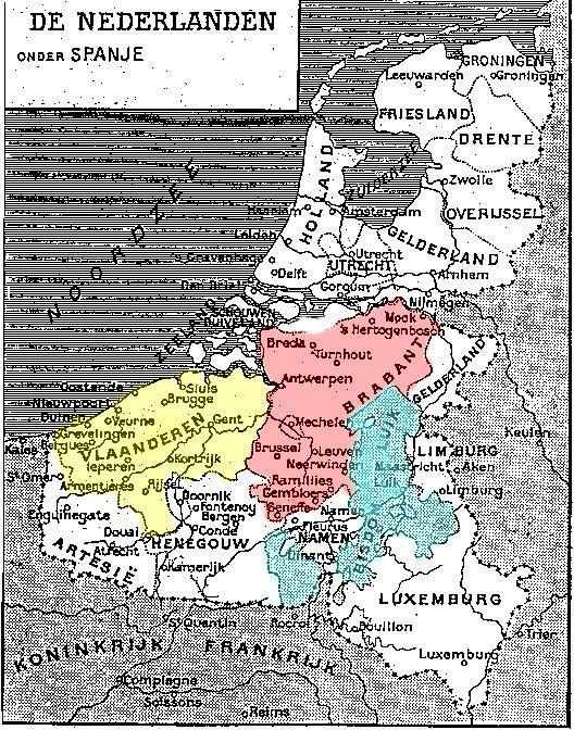
Theoretisch tot 1648, maar in de praktijk slechts tot 1585 (de verovering van Antwerpen door Alexander Farnese) vormden de Verenigde Nederlanden één gebied onder Spaans gezag. Deze eenheid was in het midden van de 15de eeuw tot stand gekomen onder Filips de Goede, hertog van Boergondië. Het Spaanse gezag was een gevolg van het feit dat Karel V zowel de Nederlanden als Spanje erfde van zijn grootouders Maria van Boergondië en Maximiliaan van Oostenrijk.
Het gebied strekte zich uit van Artesië en Luxemburg in het zuiden tot Friesland en Groningen in het noorden. Alleen het Prinsbisdom Luik genoot een enigszins onafhankelijk statuut: de hertog van Boergondië was "voogd" van de Prinsbisschop.
Op de kaart hebben we de drie gebieden met de voornaamste politieke betekenis (tot 1600!) ingekleurd: Vlaanderen, Brabant en Luik.
Vlaanderen bestond uit de huidige geografische gebieden: Frans-Vlaanderen (nu Frankrijk), West-Vlaanderen, Oost-Vlaanderen en Zeeuws-Vlaanderen (nu Nederland).
Brabant omvatte de huidige Belgische provincies: Waals-Brabant, Vlaams-Brabant, het Hoofdstedelijk Gewest Brussel, Antwerpen en de Nederlandse provincie Noord-Brabant.
Luik omvatte toen ook grotendeels de huidige Belgische provincie Limburg.
°°°°°°°°°°°°°°°°°°°°°
Theoretically till 1648 but in practice till 1585 only (conquest of Antwerp by Alexander Farnese) the United Netherlands built one country under Spanish rule. This unity was formed in the middle of the 15th century under Philip the Good, duke of Burgundy. The Spanish rule was a consequence of the fact that Charles the Vth inherited the Netherlands and Spain from his grandparents Mary of Burgundy and Maximilian of Austria.
The country reached from Artois and Luxemburg in the South to Friesland and Groningen in the North. Only the Principality of Liège had with its Prince-Bishop a more ore less independant status: the duke of Burgundy was his "tutor" only.
On the map we coloured the three regions with the most important political influence (till 1600!): Flanders, Brabant and Liège.
Flanders contained the present geographical regions: French-Flanders (now France), West-Flanders, East-Flanders and Zeeland Flanders (now the Netherlands).
Brabant was composed of the present Belgian provinces: Walloon Brabant, Flemish Brabant, the Capital Region Brussels, Antwerp and the Dutch province North Brabant.
The Principality and diocese of Liège contained an important part of the present Belgian province of Limburg.
°°°°°°°°°°°°°°°
zie ook: http://www.ancestry.com/ancestry/FreeImages.asp?ImageID=395